Once upon a time there were simple decoder rings for kids, used as promotional devices for breakfast cereals. They offered a substitution of a letter for another letter; two kids, each with a ring, could send coded messages to each other, notes that outsiders could not understand.
Is the Department of Homeland Security engaged in a similar maneuver in it latest, largely commendable, proposed reforms of the EB-5 program? Is it sending a hidden message to the EB-5 middlemen, understandable only to them, that the proposed reform looks a lot fiercer than it really is?
It all revolves around a map that first appeared on the internet, and then, later, in a much less readable way in the Federal Register. The real insiders could be expected to read the first version while everyone else saw the second version.
I know this sounds like a conspiracy theory, but before I get into it, let's set the stage.
The Background. The EB-5 or immigrant investor program offers a family-sized set of green cards (ultimately) to alien investors who place $500,000 in investment pools authorized by, but not guaranteed by, DHS. These investments are supposed to be made in depressed areas, defined as having 150 percent of the nation's unemployment rate. The program allows for the definition of targeted employment areas (TEAs) by, in effect, the promoters of what usually are urban real estate deals.
What has happened over time is that supine bureaucrats have allowed creative middlemen to draw fanciful TEAs in which the census tract where the project is to be built — usually a glitzy downtown location — is joined to a gerrymandered string of other census tracts that, collectively, meet the 150 percent of unemployment criteria. One day, in about an hour, I created such a tract that would allow an EB-5 project to be built across the street the from the White House, on the grounds that the president's mansion was in a depressed area, as we reported at the time.
Subsequently, and just before the Obama administration (which loves the program) disappears into history, DHS issued a generally commendable proposal for changing the program in the future — something that the administration could have done years earlier. As noted in a prior posting, the proposed new regulations would make major improvements in two areas: It would almost triple the amount of money needed to get the green cards and it would cause the TEAs to be less gerrymandered, requiring them to consist of the census tracts where the projects actually are and other tracts physically adjacent to the development tracts. The other major problem with the EB-5 program — the extensive fraud routinely not noticed by either the investors or DHS (but sometimes picked up by the Securities and Exchange Commission) — seems not to be addressed by the proposals.
To illustrate what the proposed TEAs would look like, DHS published a map — and now the story becomes murkier.
The Coded Map. What DHS could have done, and spared themselves some controversy, is to have drawn a theoretical map showing a census tract where a project was to take place, and a half-dozen to dozen other tracts that touch it. This would illustrate what the proposed TEAs would look like on a map.
Instead, for reasons unknown, the agency decided to take a real piece of American geography and then fuzz up the reproduction in the Federal Register to obscure the location. However, there was an interim step — the publication of an advanced text of the proposed regulations, in which the fuzziness was not sufficient to hide the location from a careful observer. Was this two-step process a deliberate way of sending a message to the politically powerful, richly funded band of EB-5 middlemen, or was this just clumsiness? I will let the reader decide.
What happened was that the advance text carried a prototype map on p. 43 of a long document. The same map, as reproduced in the Federal Register is too small for ready identification.
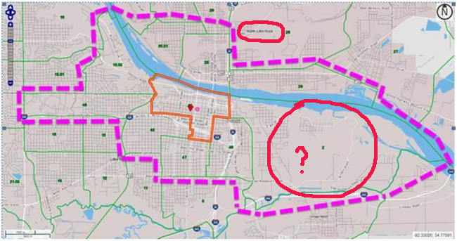
What the advance text showed was a census tract in which a project could be placed, along with nine other census tracts adjacent to it, one of which is adjacent only through a diagonal meeting of the lines.
One sees, in the advance text, a river running from one end of the map to the other, and in small, blurry type "North Little Rock".
If you check a detailed map of Little Rock, Ark., on Google it becomes clear that the TEA is centered on downtown Little Rock. You will notice, incidentally, that the Google map shows that there is "Bill and Hillary Clinton National Airport" in what would be the eastern part of the TEA, but though "North Little Rock" is readable on the advance text map, the airport is not present. (Did the DHS staff decide that the Clintons were history and should be scrubbed from the map? Who knows.)
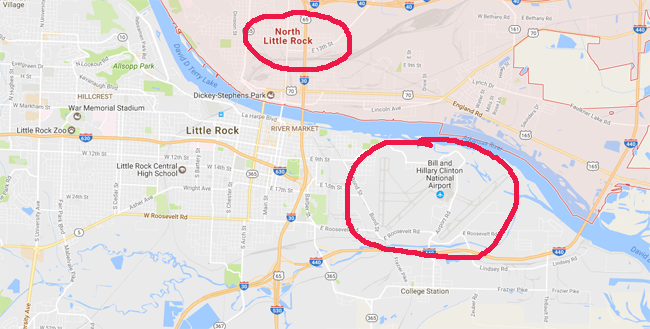
If you look a little more closely, you can see that Pulaski County census tract 44 is where the project will take place, and that nine other tracts are adjacent and identifiable.
Now let's turn to numbers. Currently BLS data indicates that Little Rock has a lower unemployment rate than the state of Arkansas in general and that Arkansas has a lower rate than the nation. This might suggest to the unknowing that it would be hard to construct a TEA in Little Rock with the requisite 150 percent of the nation's unemployment rate.
Not so. Here's the hidden message that may or may not have reached the EB-5 boosters: Even using the new, stricter rules about EB-5 design, you can draw a TEA in a city with below-average unemployment rates and still find it sufficiently depressed to "justify" the use of an EB-5 investment.
The table below shows the 10 census tracts I believe are in the map, with average unemployment rates for the years 2011-2015. These add to 13.9 percent for the TEA, in years when 150 percent of the nation's average unemployment rate was about 11.4 percent. Hence the map shows a viable location for a multi-million dollar EB-5 project.
Table 1. Census Tracts for Pulaski County, Arkansas
| Census Tract | Number in Labor Force | Number Employed | Number Unemployed | Unemployment Rate |
| 2 | 440 | 386 | 54 | 12.3% |
| 15.02 | 2,644 | 2,334 | 310 | 11.7% |
| 25 | 789 | 648 | 141 | 17.9% |
| 26 | 455 | 363 | 92 | 20.2% |
| 30.01 | 1,357 | 939 | 418 | 30.8% |
| 44 | 1,008 | 1,008 | 0 | 0.0% |
| 45 | 1,127 | 820 | 307 | 27.2% |
| 46 | 1,917 | 1,642 | 275 | 14.3% |
| 47 | 1,510 | 1,348 | 162 | 10.7% |
| 48 | 1,770 | 1,717 | 53 | 3.0% |
| Totals | 13,017 | 11,205 | 1,812 | 13.9% |
Source:American Factfinder
, American Community Survey Five-Year Estimates (2011-2015), Table B23025 "Employment Status for the Population 16 Years and Over", census tracts for Pulaski County, Ark.
So, Bingo. Even though the EB-5 project will be placed in a city with a below-average unemployment rate, and even though there is a zero percent unemployment estimate in the census tract (44) where the investment is to take place, you can still call the local TEA an area of above-average unemployment, and put the investors' money into a real estate project there.
Is that the secret message that DHS is signaling to the EB-5 promoters? That they shouldn't worry too much about these proposed reforms?
That Zero Unemployment Rate. I should hasten to add that the census tract data used in EB-5 justifications are estimates and though the Census Bureau methodology is generally sound, estimates for a small area, based on a small sample, will have margins of error that may, as in the case of Pulaski County Census Tract 44, lead to zero percent unemployed.
That a prosperous, if perhaps lightly populated downtown tract might have a very low unemployment rate and that an adjacent one (Tract 30.01) could have a very high one, is certainly within the realm of possibility.
Speaking of possibilities, it is quite possible that what looks like a hidden message could be nothing more than staff ineptitude, accompanied by the all-too-frequent, all-too-casual reviews by DHS proof-readers and program managers.
Devious or dumb? If DHS reacts, it probably will opt for dumb.